ESRI software
/in Products /by admin9892ESRI SOFTWARE
ESRI OFFICIAL ITALIAN RESELLER
ARCGIS FOR DESKTOP WITH THREE LICENSE LEVELS: BASIC, STANDARD AND ADVANCED
ArcGIS for Desktop is the Esri software providing a wide range of advanced GIS tools allowing the models, relationships and trends characterizing the geospatial data, highlighting what is often not easily deducible from a database, a calculation sheet and a statistical analysis tool.
ARCGIS FOR DESKTOP EXTENSIONS
ArcGIS for Desktop Extensions are optional modules, providing an added specialized functionality to ArcGIS for Desktop core products. Each extension provides specific tools to perform analysis or to increase productivity such as geoprocessing raster, 3D data analysis or data conversion into less popular formats.
ARCGIS FOR SERVER WITH THREE LICENSE LEVELS: BASIC, STANDARD AND ADVANCED
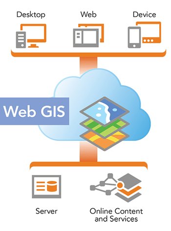
Each of these three levels is in turn available in the two capacity classes Workgroup and Enterprise. ArcGIS for Server allows the GIS services creation, management and deployment on the Web to support heterogeneous client applications on desktop, mobile and web environments.
ArcGIS for Server facilitates the GIS services access to geographic information professionals, field operators all the users without GIS technology experience.
ARCGIS FOR MOBILE
Mobile GIS – Mobile solutions for every organization. Apps for Smartphones and Tablets. The apps developed for smart devices allow you to extend the potential of GIS enterprise to a large amount of users.
ArcGIS for Windows Mobile is the ideal tool for those organizations needing to distribute data and GIS functionality from centralized servers to a wider range of mobile devices. ArcPad is the professional mobile application allowing an high accuracy data collection ensuring high productivity on field operations.
ARCGIS ONLINE
The subscription allows to manage users profiles and ArcGIS Online map data and services access levels.
ArcGIS Online is the cloud platform, “ready to use”, to create and share maps, applications, data and geographic content, thanks to the wide basic geographical data collection access with a worldwide coverage.
ArcGIS Online is the management platform for organizations and companies allowing the creation of maps and applications to share with their users, through ready-to-use content, applications and template. The platform is available via web and can be used also with smartphones and Tablets. It does not require installation and configuration operations and is simple to use.
ESRI CITYENGINE
CityEngine is Esri software to easily create high-quality 3D models from two-dimensional data. CityEngine provides 3D environments modeling, urban planning, architecture, defense, simulation, game development and animation production.
CityEngine allows an efficient design and a rapid creation of virtual 3D urban environments from two-dimensional data.
CityEngine makes easier the GIS data usage creating geographically accurate models for urban design, historical reenactment, or cities realistic models. In addition, it provides the support for georeferenced data formats such as Esri File Geodatabase (GDB) and KML. The interface user is facilitated thanks to the drag-and-drop data import functionality.
GEOGRAPHICAL DATABASES CREATION AND UPDATING
TECHNICAL ASSISTANCE OF GIS PLATFORMS MANAGEMENT ON ESRI AND / OR OPEN SOURCE TECHNOLOGY, BOTH FOR DESKTOP, WEB AND MOBILE ENVIRONMENTS
The iptsat technical assistance is aimed to the GIS platforms management optimization providing a fundamental help in its use and in particular giving a valuable support in the GIS solutions creation and optimization phase of design and for any problem concerning the data and GIS software management.
CLOUD GIS AND CATALOGUES
Geographical platforms annual hosting services at our equipped server farm, give us your data and we’ll take care of the rest
FAROS
Supply of precision agriculture maps…. soon online
ArcGIS is a complete GIS system allowing to the organizations an added value decisional and operational making, through the application of geographical knowledge. Iptsat is partof the Esri Partner Network and the Esri Italia Business Network, dealing with sale, assistance and development of ArcGIS software customizations

ESRI software: ArcGIS platform.
ArcGIS for Desktop is Esri’s software providing a wide range of advanced GIS tools allowing the models, relationships and trends identification, characterizing geospatial data, highlighting what is often not easily deducible from a database, a spreadsheet and a statistical analysis tool.
In addition to data visualization as geometric elements on a map, ArcGIS for Desktop allows its management and integration, advanced spatial analysis, modeling, with the possibility to automate operational processes and display results on professional quality maps.
ArcGIS for Desktop is available with three license levels: Basic, Standard, and Advanced (formerly known as respectively ArcView, ArcEditor and ArcInfo).
ArcGIS for Server allows the GIS services creation, management and deplyment in order to support the heterogeneous client applications in desktop, mobile and web environments. ArcGIS for Server facilitates GIS service access to geographic information professionals, field operators and users without experience in GIS technology.
ArcGIS for Server ensures the ability to centrally manage all the GIS data, vector, image and raster. Projects can be prepared in the ArcGIS for Desktop environment including GIS maps and tools, to be transformed into ArcGIS Server services accessible to enterprise and web environments. Another feature of ArcGIS for Server is scalability, allowing the installation on a single system, in order to support small workgroups, or the distribution on multiple servers typical of an Enterprise environment, ensuring the effective functioning of a large number of users even on considerable amounts of data.
Furthermore, ArcGIS for Server can also be implemented on the most popular Cloud-type infrastructures.
ArcGIS Online is the cloud platform, “ready to use”, capable of creating and sharing maps, applications, data and geographic content, thanks to the access of a wide basic geographical data collection with worldwide coverage. ArcGIS Online is the management platform for organizations and companies providing the creation of maps and applications to be shared with their users, through ready-to-use content, applications and template. The platform is available via web and can also be used with smartphones and tablets. Simple to use, it does not require installation and configuration operations.
ArcGIS Mobile Apps for Smartphones and Tablets: Apps developed for smart devices allow to extend the enterprise GIS potential to a large number of users. ArcGIS for Windows Mobile: the ideal tool for all those organizations distributing data and GIS functionality from centralized servers to a wider range of mobile devices. ArcPad: is the professional mobile application allowing an highly accurate data collection, ensuring field operations high productivity.
In-depth link: ArcGIS Online
Geomonitor
/in Products /by admin9892GEOMONITOR
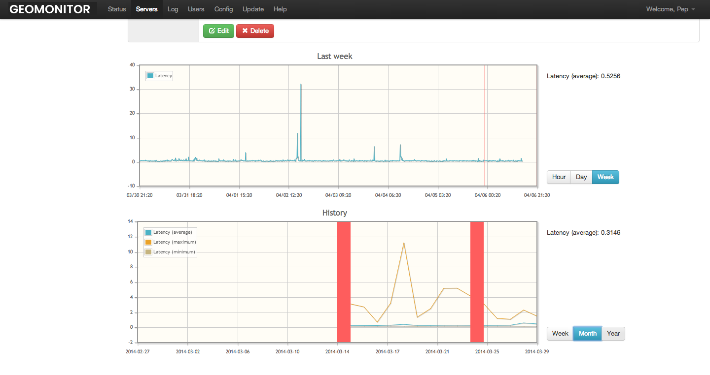
Cloud system for remote server requests supervision. The system “ping” services, ports, sites sending notifications on any possible applications, sites and hosts “down”. Notifications are sent by email or by telegram.

Faros
/in Products /by admin9892FAROS PROJECT
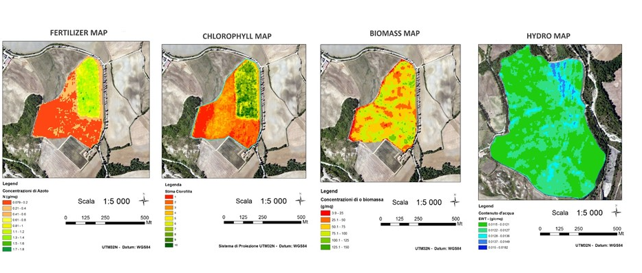
The main objective of the FAROS project is to launch an innovative service concerning precision agriculture with the creation of maps produced by earth observation data. Through the integration of satellite data derived from the new Copernicus constellation and in particular from the upcoming satellite launch, Sentinel 2 combined with GIS technologies FAROS intends to develop an agricultural information system allowing even the less experienced users to employ maps derived from satellite data within their production process to optimize production, decrease the pesticides and herbicide use and respect the environment.

Winner of phase 1 SME Instruments
The strenght maps allow you to monitor crops force with considerable detail, by “Photographing” the vegetative state and quantifying the photosynthetically active biomass. For each field the map use a chromatic scale in n shades, from red to dark green, to indicate n different levels of vegetative strenght (red: minimal vegetative force; dark green: maximum vegetative force). In this way, each field or sector of it is divided into n classes of force, each one equal to approximately 1 / n of the entire parcel surface.
For each parcel, the maps are produced in 2, 3, 5 and 10 classes, in order to provide the user with a wide range of predefined opportunities concerning this technology different possible repercussions and field applications.
These maps supply to:
- obtain a production increase
- fertilizations best manage
- be aware of risk areas
- increase products quality
For information: http://faros.iptsat.com/
Biogis
/in Products /by admin9892Biogis 360
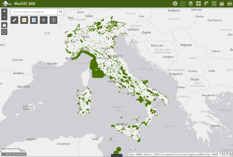
BioGIS 360 is a fundamental tool for biodiversity monitoring, developed by iptsat in collaboration with the Department of Environmental Biology (DEB) of La Sapienza University of Rome offering “one-stop shop” data research for all those seeking authoritative information on biodiversity worldwide (or at national level).
BioGIS 360 provides to companies an essential aid with the integration of considerations, reporting and biodiversity maps in their decision making aspects, in order to simplify the information exchange and promptly mitigate and manage the possible environmental impacts during the works planning.

Tags
Links of interest
Rome office
Via Sallustiana, 23
00187 – Roma
+39 0642041717
+39 0642041703
info@iptsat.com

