EMERGENCIES
Both historical and up-to-date GIS and geospatial data provide powerful tools to support public administrations and companies interested in prevention and consequently management of all the emergency phases (prevention, mitigation, response and recovery) resulting from natural and environmental disasters. Here some activities to support:
- Supply of satellite images in “near real time”
- Potential disasters mapping and modeling in order to visualize vulnerable areas, critical situations and potential harm
- Data visualization and location to carry out real time analysis
- Emergency situations awareness and visualization
- Recovery activities, humanitarian actions and reconstruction
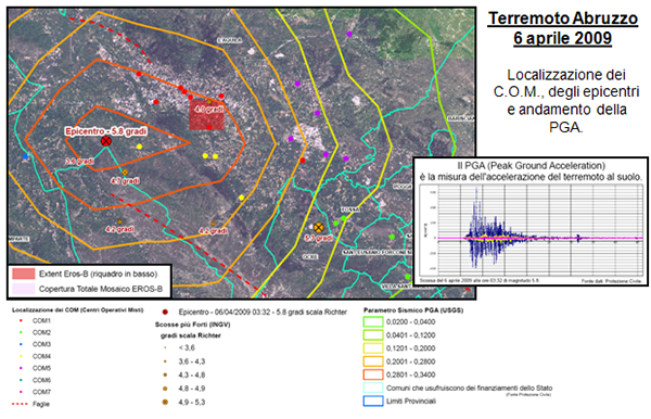
Abruzzo earthquake 6 April 2009 – C.O.M.and epicenters localization and PGA trend.
RISK ANALYSIS
Environmental and territorial risk analysis is critical in the emergency management. The overall sight of the environmental condition and the available data are of primary importance to manage an emergency. The GIS system is a valid tool in the disasters prevention phase for the interventions planning, the available resources organisation, the simulation, the study of previous situations, etc.
Newkirk (1993) explained how a GIS offers potential disasters critical points of view and their impact both before an event and post-event analysis. His concern is that the GIS encourages the user to believe in its accurate data. The system should allow a broader risks examination and its potential or actual impact by estimating validated data a priori, applying extra pre-configured environmental variables.
The advantage of a GIS system is to provide information to improve decision-making processes connected with emergency planning in its different phases, containment, analysis, future planning. A GIS is capable of providing maps at regular intervals and, used together with satellite data, it allows to redesign, in real time, the places new condition. During an emergency management, the GIS provides a significant support to decision making, for example in the calamity evolution analysis and in the calculation of the resources used, in the internal resources management (personnel, equipment, etc.)and finally in the damages assessment and estimation.
The creation of a modern and efficient GIS system is carried out through computerized forecasting, prevention and management emergency functions typical of those Institutions which, due to their institutional task, during a disaster event must safeguard and protect both population and works. The creation of a valid communications system capable of providing and updating databases both in ordinary circumstances (cartographic, technical-
administrative and alphanumeric) than in an emergency phase is the target to pursue for a quick and effective organization. This management ensures the synergy between information technologies and telematics to provide a homogeneous system of decision making support, during the pre and post-emergency.
IPTSAT RISK HAZARD DATABASE
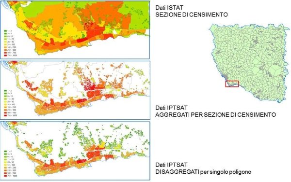
Based on the experience gained over the past 15 years, as well as the participation to various Italian and European projects on the geographical databases structuring, in 2015 Iptsat developed the logical model, the database algorithm relating to the potential risks analysis deriving from both human and natural impact . The database is made up of a series of data derived from institutional sources and proven efficiency commercial database, developped with the scientific collaboration of some important national institutions.
Send an email to request an extract of the demo database
HEALTH
Only nowadays the health sector benefits from GIS enormous potential. Both the public and private sectors are developing innovative ways to take dvantage of data integration and spatial visualization power of the GIS. The kind of companies and organizations adopting GIS totally enclose the health care industry: from public healthcare departments, research organizations and health politics to hospitals, medical centers and health insurance organizations.
Furthermore, gis represents a fundamental tool to manage health statistics by mapping and depicting specific areas, as widely proved during the last pandemic period.


