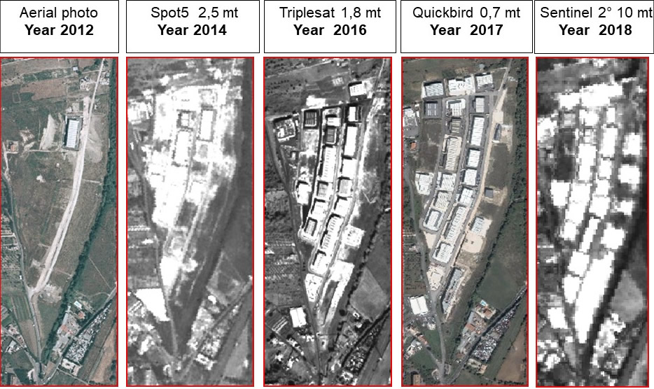
DISTRIBUTION OF SATELLITE IMAGES
GEOREFERENTIATION
Two dimensional image correction process capable of associating known reference system real coordinates to an object within the image.
ORTHORECTIFICATION
Three dimensional image correction process (much more accurate than georeferencing) allowing the remote sensing image correction, in particular limiting the deformations occurred in the shot phase and those connected with the instrumentation used
RADIOMETRIC CORRECTIONS
Effects corrections due to the sensor sensitivity and the lighting different conditions.
ATMOSPHERIC CORRECTION
Radiance values distortions are the consequence of the atmosphere different layers crossing.
Atmospheric correction helps removing such disturbances.
Atmospheric correction is particularly important when multitemporal data must be compared and analyzed.
PATCHWORK AND BALANCING
Our software allow the generation of multiple images homogeneous patchworks in a short time: working on the colour balance, the results are excellent even starting from radiometrically different images.
AGRICOLTURAL INDEXES MAPS
it is possible to define quantitative dealings with vegetation spectral behaviors analysis in order to discriminate vegetation from other types of land use through the use of algorithms based on the typical spectral bands of absorption and reflection ratio.
THEMATIC AND DERIVATIVE MAPS
It is possible to extract value-added information of derived maps and specific themes forms, through remote sensing data process classification and photointerpretation Eg: land use maps, vegetation maps, slope maps, temperature maps
CHANGE DETECTION
Change Detection is the satellite remotely sensed image processing technique which purpose is to identify all the transformations occurring in a given territory over the time.
ORTOPHOTOCHARTS
An orthophotochart is essentially formed by a satellite ortho-image framed in a cartouche. A kilometric grid, a geographical grid and a cartouche with a series of added information are of main importance in order to facilitate its use and to frame the ortho-image in the chosen reference system
CARTOGRAPHY CREATION AND UPDATING
You can update the vectorial pattern of geographical database throuh a 2D and 3D cartographic return.
E.g .: CTRN, topographic DBs …
3-DIMENSIONAL SPACE ORIENTATION OF IMAGES ACQUIRED IN STEREOSCOPY
The stereoscopic vision allows to perceive three-dimensionality.
The images oriented in the three-dimensional space allow the acquisition of the stereoscopic vision and the images preparation for the 3D data extraction, both elevation models and photo-returned extracted objects.
DEM (DSM)
A Digital Elevation Model (also known as DEM, from the English Digital Elevation Model) is the representation of the territory or other surface distribution share in a digital format.
The digital elevation model is generally produced in a raster format, associating to each pixel the absolute quota related feature (NTT DATA ALOS DEM / DTM 5m).
DTM
For the most part of practical applications, the interest surface to model is the terrestrial soil surface. In this case we speak more precisely of Digital Terrain Model or briefly DTM, from the English Digital Terrain Model. A DTM is therefore a particular type of DEM (NTT DATA ALOS DEM / DTM 5 m).
The Planet high resolution multispectral satellite data and / or other satellites (Geoeye, Ikonos, Worldview, Spot …) images usage and the specific GIS and Remote Sensing know-how, together with the scientific coworkers support and (if necessary) the ground and / or other data sources surveys, allow to Iptsat added value high quality solutions and service proposals and new projects specifically designed on customer needs.
SATELLITE IMAGES CORRECTION AND PREPARATION SERVICES
Iptsat provides geometrical and radiometric correction services on any image acquired with optical sensors, with the following processing:
TOA (Top of Atmosphere) radiometric calibration: Reflectance value calculation at the top of the atmosphere (The various solar lighting conditions are standardized to different acquisition times).
Ground Atmospheric Correction: Calculation of the Ground Reflectance value (removing the atmosphere effects on the image).
Orthorectification: data can be orthorectified in different ways with or without GCP (Groundcontrol point) depending on the accuracy required, with the following methods:
- Orbital model using GCP
- Rational functions using RPC (Rational Polinomial Coefficient) with or without GCP
- Rational functions using GCP Stereoscopy orientation:
Orientation of two or more images acquired in stereoscopy for 3d information extraction applications (dem extraction, 3d photo-restitution).
CHANGE DETECTION AND HISTORICAL ANALYSIS
Change Detection is the processing technique of high-resolution satellite remotely sensed images acquired in different moments, for the identification and / or discrimination of the environmental and urban variations over the time.
In the updating territory analysis procedure, high-resolution satellite data are georeferenced and orthorectified according to the same aerial photos reference system previously used. The Change Detection is a useful step to keep track of variations not detectable otherwise within the official records or by sample surveys.
The satellite images used offer real and updated information thanks to the geometric high degree detail. These products allow urban and extra urban territory supervision, at regular ranges, hence following the territory development over the time.
The Territory Analysis Technique allows to take a census of the timeframe changes by comparing multitemporal data.
DEM – STEREOSCOPY
A digital elevation model (also known as DEM, from the English Digital Elevation Model) is the representation of the territory, or other surface, shares distribution in a digital format. DEM can be produced with different techniques. Generally, the finest models are realized through remote sensing techniques involving radar or satellite stereocouples image processing.
Digital terrain models (DEM) usage is fundamental in many applications such as map generation, environmental monitoring, geospatial analysis, telecommunication engineering and more. Iptsat generates Dems from satellite images acquired by stereoscopy.
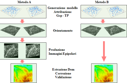
Iptsat methods include: the use of an orbital model, the attribution of points of control (Gcp) and homologous points (TP), the subsequent orientation of images, the generation of epipolar images (optional), the Dem extraction, correction and validation.
Through the partnership with NNT DATA and RESTEC, Iptsat distributes 3D worldwide data AW3DTM covering the whole world showing the ground undulations with highest resolution available on the market (5 METERS) using ALOS, the Japanese spatial agency, satellite PRISM data.
In-depth link: Asita 2014
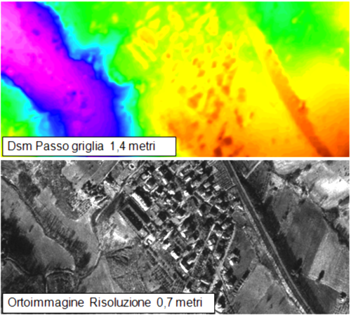
Example of DSM extracted form High resolution data.
CTRN AND DBT
The “Regional Numerical Technical Map” (CTRN) constitutes the basis reference for the municipal urban planning tools drafting, the Provincial Coordination, the Area and all the regional planning and programming different branches plans.
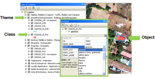
Satellite images and their processing are of fundamental support for the CTRN realization or update. Iptsat developped a way to reprocess and redefine the CTRN information as topographic geodatabases. The Lazio DTP (Topographical Database) implemented Domains and Template outline is already available on the Esri platform.
Geodatabase Eample “DBT Regione Lazio” on ArcMap Template.
ORTHOPHOTOCHARTS
The orthophotocharts can be considered as basic cartographic data, common use classic cartography supplementary or replacement (ctr, IGM cartography etc). Their use fits into a context in which there is a lack and/or total absence of updated cartographic data. The first situation occurs when you want to obtain an updated cartographic product, in a short time and at a reduced costs, having the same cartographic information requirements and the same level positional accuracy of traditional cartography.
The second situation frequently occurs in developing countries where a cartographic datum of reference is lacking; as a matter of facts, in the African countries, Albania or in other contexts orthophotocharts replace traditional cartography.
The main advantages of using Orthophotocharts are: lower production costs compared to traditional cartography, specific territory direct perception
and a drastic reduction in the cartography updating times especially in case of satellite data utilization. An orthophotochart is essentially formed by a satellite ortho-image framed in a cartouche.
To facilitate the ortho-image use and frame in the chosen reference system, a kilometric grid, a geographical grid and a cartouche with a series of further information are fundamental.
Example of the “DBT Lazio Region” Geodatabase on ArcMap Template.
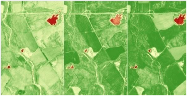
VEGETATION INDEX MAPS
Thanks to multispectral and multitemporal remote sensing data processing, Iptsat is able to create vegetation index maps, essential for the state and change of agricultural, forest and vegetation resources classification and supervision:
NDVI and NDVI Red Edge Index Maps: Show the plant strenght differences Index maps fPAR and LAI: calculate the photosynthesis surface, the evapotranspiration and the net annual primary production estimation TCARI and MCARI index maps (Chlorophyll maps): show some plants nitrogen nutritional status OSAVI index maps: this index, thanks to the combination with the soil line, improve the reflectance contributions of the surrounding environment and the change sensitivity in the leaf chlorophyll content
Example of multitemporal NDVI index map (Val d’Orcia) processed by RapidEye satellite data
